Tuesday, June 19, 2012

Makapu'u Lighthouse Hike


The Makapu'u Lighthouse Hike is a 2 mile hike located on the western most tip on O'ahu.  I would say this is one of the most easiest hikes that I have done here on O'ahu.  The trail is basically completely paved all the way to the viewing stations on top.  There is a slight incline but not excessively steep.  This was the first hike I completed upon moving to Hawai'i.  It is hot and dry on this side of the island, so bring water.  During this hike, we actually got rained on which is unusual.


We brought along our dog Jack and we bring along doggy bags to be environmentally friendly.  He loved going on this hike, mostly because it is a really popular hike with lots of other dog lovers bringing their dogs also. So lots of spots to sniff and pee on all the way up the trail.

 You have great views of Koko Head Crater and the beautiful blue Pacific Ocean


Makapu'u Lighthouse


A point of interest for a unusual thing to do would be to bring up an engraved lock to place on the wall of the top viewing station.  The locks seem to be memorials for lost loved ones or anniversary dates.  As you can see in the picture below, there are quite a few locks..


The next time we do this hike, I would like to add on a slight side hike down off the beaten path to the Dragon's Nostrils. You go up a little over half way and then take a side path down to the rocks below.  This is not a marked or paved path, more of foot path that locals or avid hikers know about. Its suppose to be really awe inspiring when the waves are really going.  Had friend's describe unwary tourist almost get pulled out to sea because they were not being careful of the waves on the rocks.  So be careful if you do complete the Dragon's Nostril hike addition

Friday, June 8, 2012

Manoa Falls Hike

Second most popular hike done on Oahu after the Diamond Head Hike.  I can see why, this hike is only two miles round trip with a small evaluation change (400 feet over 0.8 miles).  The surround rainforest was a beautiful to blaze through as we were power walking to the falls.  EXPECT to get muddy, really muddy.... Though not the muddiest trail I have ever been on. I could tell by its location up in Manoa Valley, it probably stays muddy though.

We wore proper hiking shoes.  Tennis shoes for me, hiking sandals by my boyfriend. I always seeing people hiking wearing flip flops.  Really flip flops? One woman skidded in front of me as she was coming back from the falls going down hill.  It might be better just to go barefoot then to wear flip flips on muddy terrain.

We washed our feet before even starting the hike to get rid of any invasive plant seeds that might be stuck to the bottom of our shoes. There is a nice foot washing station located next to the paid parking area just for that purpose.  Though I suspect most people just use it to wash up after they completed the hike.  We did both, washed up before we got in the vehicle.


Manoa Falls Trail is a dog friendly hike as long as you keep your dog on leash and hike the dog poop out with you.  We bring our dog Jack's poop bags and flattenable water bowl with us on hikes.   We really moved fast on this hike mostly because Jack was setting the pace.  We did get to enjoy some good rainforest views though.  We ran into a lot of people on this hike, at all different hiking levels.  So passing or being passed is just par for the course on this trail.  Some spots you need to wait for people coming from the opposite way to get past before climbing up or down yourself... just stand to the side and smile....
 I enjoyed this hike but it was a little short for me, I could have done another mile or two no problem. We completed the hike in less then an hour.  We thought about adding the 'Aihualama trail to our hike but because the general muddiness decided against it.  Maybe on a less muddy day.


So I think our big highlight of the hike was actually an aggressive marauding chicken that sprang out of the brush near the trails beginning and tried unsuccessfully to attack my dog Jack.  With the use of my foot as protective shield neither dog or fowl was injured... This is the second time a chicken has attacked him, the first time it was through a wire fence and the chicken pecked him on the nose.

Sunday, May 27, 2012

Lanikai Pill Box Hike

View from Last Pill box
Lanikai Pill Box Hike- a shorter hike best done either in the early morning or later in the day.  Very hot and very dry - almost reminded me of Kaena Point but a lot shorter. We did this hike at 10:30 in the morning and it was still very busy.  This hike had been on my wish list for a while because I have seen other peoples pictures and saw how gorgeous the Pill boxes and views were.  From the top of the trail you can see Lanikai Beach, which is where we headed afterwards to barbeque.  The Pill boxes are left over from WWI and WWII, they were observation posts to alert defenses of approaching enemy ships.  They are now empty out and graffitified, but the graffitti actually adds points of interest inside the pillbox.
View from the Trail - Looking down on Lanikai Beach


 We found the trail head and marched up a steep dirt path for about 50 yards, by the end of which I was extremely winded.  There are rope handrails on the side which you will probably need on the way back.   Now that was the hard part, the rest of the trail is less steep incline.  You do get to climb up some easy rock faces on the way up and I did the butt scoot on the them the way down.


Now lets get back to the first 50 yards steep incline area, I fell flat on my booty on the way down.  Loose dirt plus steep slope equals perfect falling conditions.  Someone broke their ankle on this trail the day before so be careful. Use those rope handrails.  I really did enjoy this hike and would suggest it to anyone who wants to do a shorter hike, it took us maybe 45 minutes to complete the hike all together. 


On Top of the Last Pill Box

Thursday, July 21, 2011

The Giant - an Alaska Hike


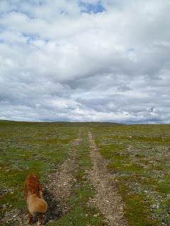
The Giant is a large formation of rocks on top of mountain located at 60-61 mile on the Kourgarak road system outside of Nome, Alaska.  Our family camp is located at the Pilgrim river bridge. So as a family , we hike to the Giant often.  The trail is about 3 miles round trip with great views of the Pilgrim River Valley and the Kiglualik Mountain Range.
So after you cross the Pilgrim River bridge, you are looking for the trail.  The trail is actually a ATV trail.  You can blaze your way across the mountain on your own but the ATV trails works its way through the Alder brush, making the trek a lot easier.  You should easily see the ATV trail and where it connects to the road.
This was a family event, my parents just got married and so a whole bunch of family:Aunts, Uncles, Cousins were in town.  Last year, my Aunts and Uncles had come up to Nome to bury the ashes of my grandparents at the base of the Giant.  So we had an ulterior motive to do this hike.


If seen with human eyes, you would have been able to see the giant rising out of the background, but as with pictures, you don't see everything that the picture taker saw.
The Giant, I would almost rename it the fingers myself.  There is a Hawk's nest on the side and has been for as long as I have hiked up to the Giant.
The hawk's nest is the brown dot there on the very left column towards the top.  The hawks were still there, so as to not stress them out too much we stood on the other side of the Giant from the nest.
My grandparents memorial.  Doug & Alice Scott: Its started over.  Also in between the rock columns, you should be able to find a plastic peanut butter jar.  I hope you brought a pen to write down who and when hiked to the Giant. So sign away but please the jar back firmly.  The winds are strong up there.
All the way around the Giant, a field of Monkshood bloomed.  A very pretty purple flower.
This a fun and fairly easy hike, that really the whole family can do.  i would recommend 8 and older.  We did seem some bear poop along the trail and recommend bringing a gun with you. A great and fun hike around Nome Alaska.

Monday, July 4, 2011

Aiea Loop Trail

My boyfriend and I hiked the Keaiwa Heiau loop trail, or as it is more commonly known as the  Aiea Loop Trail. This is a 4.8 mile loop with very little elevation change.  There are some minor hills and rock piles and gets very narrow in a small section but overall a very easy but long hike.

First off there are three main parking areas at the Keaiwa Heiau State Park.    We parked at the second one and then walked by the road to the trail head.  This doesn't really matter because the way that the trail loops even if you park by the trail head, you will still walk up the hill in the end.  The hike started out pretty dry but we had a hint of what was coming from another hiker covered in mud.
Expect to get muddy, wear good shoes - no flip flops.   I have been on couple of hikes here in Hawaii and always see people trying to hike in flip flops.  Stop! Its a great way to break your ankle. I have a tendency to roll my ankles, so I have two types of hiking shoes - a pair of running shoes with good traction and then ankle high hiking boots. My boyfriend is modeling hiking sandals - good for people with strong ankles.  The straps on the toes keep your feet from moving around unlike flip flops.


 The trail goes through multiple lemon eucalyptus stands and gives the air a nice citrusy scent. There are also conifer trees on the side of the trail.    A couple of times, I smelled a fragrant flower in the air but could never locate the bloom. 


 Boyfriend in front of a grove of Lemon Eucalyptus.  I initially thought they might have been rainbow eucalyptus.
Dogs are allowed on this hike if on leash and well behaved.  This little guy above is named Jack and he is an avid sniffer.  Other hikers have seen boar on this trail so be aware.  There are also two boar hunting days a week on Oahu.  Which I believe are Wednesdays and Sundays.  The boars aren't what I worry about much, but the boar hunting dogs on the other hand, keeps Jack home on those days. 

This was one of the tricky parts of the hike, it was very muddy on our hike and made getting up this rock pile tricky.  Expect to straddle a couple of fallen trees that are blocking the path and maybe even duck under a few more.  The hike was worth the breathtaking views of the H3 - the most expensive road to build per mile in the US.  Get pockets of views of Aiea and Pearl City as the canopy breaks for views of the land and ocean.

It took us two hours to finish this hike.  We saw only a couple of hikers which is nice when you can feel that you are in the wild alone

Saturday, June 25, 2011

Maunawili Falls Hike

Maunawili Falls Hike - its about a 3 mile hike round trip located in Kailua, Hawaii.  This hike full filled my dream of going on a hike and swimming in a waterfall at the end.  Now that is said, swimming in fresh water streams in Hawaii may not be the best idea.  They have a bacteria in the water called leptospirosis which can cause infections -really bad ones.  Anyhow, didn't stop me from going into the water but if you have unhealed cuts, sores or lesions - stay out.  Here is a link with more information : http://en.wikipedia.org/wiki/Leptospirosis

So back to the hike, so when you arrive there is a small parking area up the road from the trail head.  The locals are nice enough to post warnings and safety precautions on a chalk board by where you park.  So you walk down the road a bit, go over bridge and then you finally make it to the trail head.  This hike is fun but wear proper footwear!  I have never seem soo many people slipping and sliding as I did on this hike.  Flip Flops are a NO NO!  It was extremely muddy and it will probably be muddy when you go too.  Its on the rainy side of the island.  

The hike, because of the mud, can be a little treacherous, be careful - find a walking stick if that helps.  But after an hour or so of watching your step, you will be rewarded by arriving at Maunawili Falls.  This is a very popular hike and there will be people coming and going by.  Not a good loose dog hike for sure.  It was a little cooler out the day that I went. So there wasn't really anyone but me in the water which was fine by me.  
 There is a rope and ledges to dive off of.  I am not advocating that all.  I guess the week before someone was jumping off one of the ledges and landed wrong and broke her back.  She was helicoptered out.  Be careful people.  But I guess a lot of people do jump off the sides of the waterfall.
The water as you can see is very murky and I have no idea where its deep or not, but I loved exploring anyhow.  I will definitely do this hike again for sure, if not just to go swimming again

Saturday, June 18, 2011

Diamond Head Hike

Diamond Head Hike - located at Diamond Head State Park near Honolulu.  Big tourist attraction, loads of people.  They bring them in by tourist bus. There will be lot of other people on this trail.  Diamond Head is an ancient dormant volcano crater and has part section off as a military installation.

We walked from our house and added an extra mile and half to the hike.  The hike itself is pretty easy until you get to the stairs.  Ahh the stairs... nearly fainted when I saw the second set because I blazed up the first set.  Paused at the bottom of the second set before trudging on, but luckily you are near the top when done.  

I have seen other people's hiking blogs and they have wonderful pics of the views and none of themselves.  Well this is my blog and I have picts taken of me while hiking and they are usually the pics I like best... So enjoy.

 This is at the bottom of the trail where if you walk in into the park, you pay a dollar each.  Most of the trail is paved and only a slight incline.

 Views from the trail.  In the background there you see parts of Honolulu.

 A view from the very top.  Diamond head in the past was a military base, with parts of it still sectioned off from the public.
A view of Waikiki and Kapiolani Park.  It's crowded at the top, not for the claustrophobic at all.  A good beginner's hike for sure.